Guatemala Revisited: Climbing Volcan Acatenango

Back in Southern Mexico, the rainy season was in full swing, and Agape was safely tied up in her slip and decommissioned. We knew that we wanted to do some inland travel of Central America over the next few months as we waited out the rest of Hurricane season. Six years prior, Rachel and I had spent five weeks traveling through Guatemala, learning Spanish and seeing some of the most unique landscapes we've ever seen. We decided that since we were only a short drive from the border we should once again pack our bags and head south to rediscover the beautiful country of Guatemala.
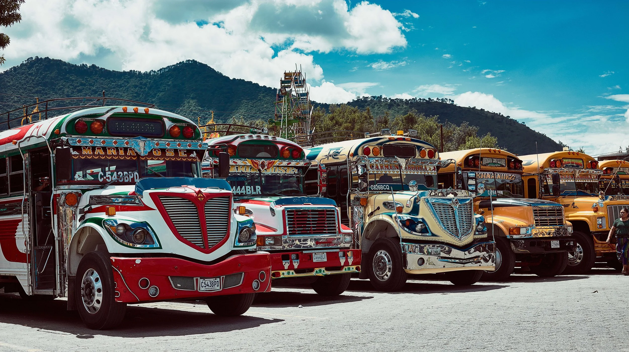
Photo by Willie Kessel
From ancient civilizations and conquistadors, to dictators and rebels, this long, narrow strip of central America has an arduous history. Guatemala's past is full of civil wars, violent coups and genocidal massacres and has somehow emerged as a diplomatic and amicable country with democratic elections and economic growth. Though Guatemala still continues to struggle with high rates of poverty, crime, drug trade and instability, the country's abundance of biologically significant and unique ecosystems have captivated travelers for centuries.

Photo by Willie Kessel

Photo by Willie Kessel
On this trip to Guatemala we decided to revisit some of our favorite places and also seek out new experiences. This time our friend Willie Kessel, a photographer from the States, as well as Nicola Morton, from S/V Juniper, and John and Becca from S/V Halcyon our buddy boat from last season, would be joining us as well as.

Photo by Willie Kessel
The plan was to meet up in the city of Antigua, located in the central highlands of Guatemala. The city once served as the country's capital and was originally founded in 1543, only to be destroyed on several occasions by violent earthquakes and volcano eruptions. Walking the old cobbled stone streets lined with 17th century Spanish Baroque churches and architecture is a constant reminder of the city's rich history.
Once we were all in the city, it was time to brainstorm some adventures for the next few weeks. Immediately, we were surprised by how much the city had changed in only six years! During our last trip to Antigua, Rachel and I had almost no money, and we had to account for every dollar we spent, but still found the city had plenty to offer and see, even for those with limited finances. Now however, you better bring your credit card because tourism has come to Guatemala in a new wave and brought along with it western prices.


Luckily this time around we had a little more money to plan some of the fun activities we were unable to do on our previous trip. John, Becca, and I went on a guided mountain bike ride through the hills and pueblos surrounding Antigua, while Nicola, Willie and Rachel went to artisan markets and the nearby town of Pastores to look for treasures. Rachel had partnered with our friend's company Soul Shapers, and was looking for some leather bags to bring back to the states to sell at auction.

Photo by Willie Kessel
We then decided we'd like to hike to the top of Volcan Acatenango, sister to Volcan Fuego, (Spanish for Volcano of Fire) that erupts daily. Everyday since the Spanish conquest, small gas and ash eruptions occur almost every hour. From the city below you can watch plumes of ash and smoke rising from the top of Fuego, but we wanted to get a little closer and had found a few companies guiding overnight trips to the summit of Fuego's sister volcano, Acatenago. We knew it would be a total suffer fest going up through the steep cloud forest and scree fields of the 13,000ft Volcano, but we knew the views would be worth it!

Early on July 18th, we headed to the trail head at the base of the volcano with Old Town Outfitters. Photo by Willie Kessel.

Hiking up through the cloud forest. Photo by Willie Kessel.
There are now quite a few guiding companies that can take you up the mountain and prices range quite a bit. If you ever plan to do this trek, make sure that before you ever sign on with one of these companies to ask to see the gear that you will be renting ahead of time. And make sure it's not the stuff they have laying in the shop but the actual backpack, sleeping bag, tent etc., as we found that some of the cheaper outfitters gear was less than adequate. Depending on the weather on your trip this may or may not be a problem, but since you are going up the side of a 13,000 ft volcano often having rain and sleet, in near freezing temperatures, you better have some least decent gear. We ended up going with Old Town Outfitters that charged $125 a person if you have a group of four or more. It included all our gear, park fees, a guide, snacks, healthy hot meals and even wine to go with dinner! It was a first class operation and we were so thankful that we ended up choosing them after seeing some of the other hikers with crappy gear and sack lunches.

Photo by Willie Kessel
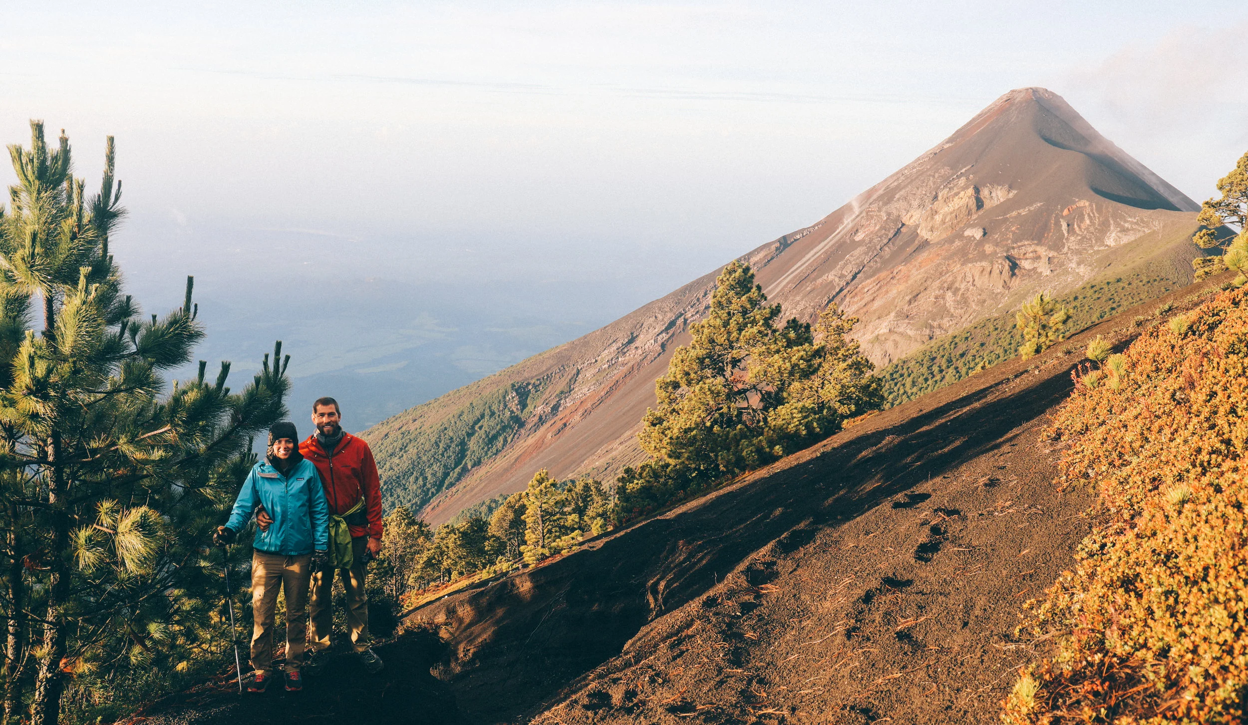
So off we went!!!! The 5,000 ft ascent winds its way up through four distinct ecosystems, starting in fertile agricultural fields where local farmers harvest corn, flowers and snow peas. Then the trail rises into old-growth tropical cloud forest and out through a sparse high-alpine forest, revealing views of six surrounding volcanoes. The final push of the day and climb above the tree line and into the fourth microclimate… a wind-swept and mystical volcanic terrain where we'd set up camp at 12,300 ft. Our campsite looked directly over Volcan Fuego.


Let me tell you, I have never been so cold in my life!!! On the way up the trail it rained so hard it soaked through all our waterproof clothes, and every time we stopped moving the wind seemed to pick up and froze us to the bone. I was so cold that I was unable to set up my own tent, my fingers just couldn't untie the knot to the tent bag. After some help from our guides, I crawled inside with Rachel and we cuddled up in our damp clothes and sleeping bags trying to warm up.
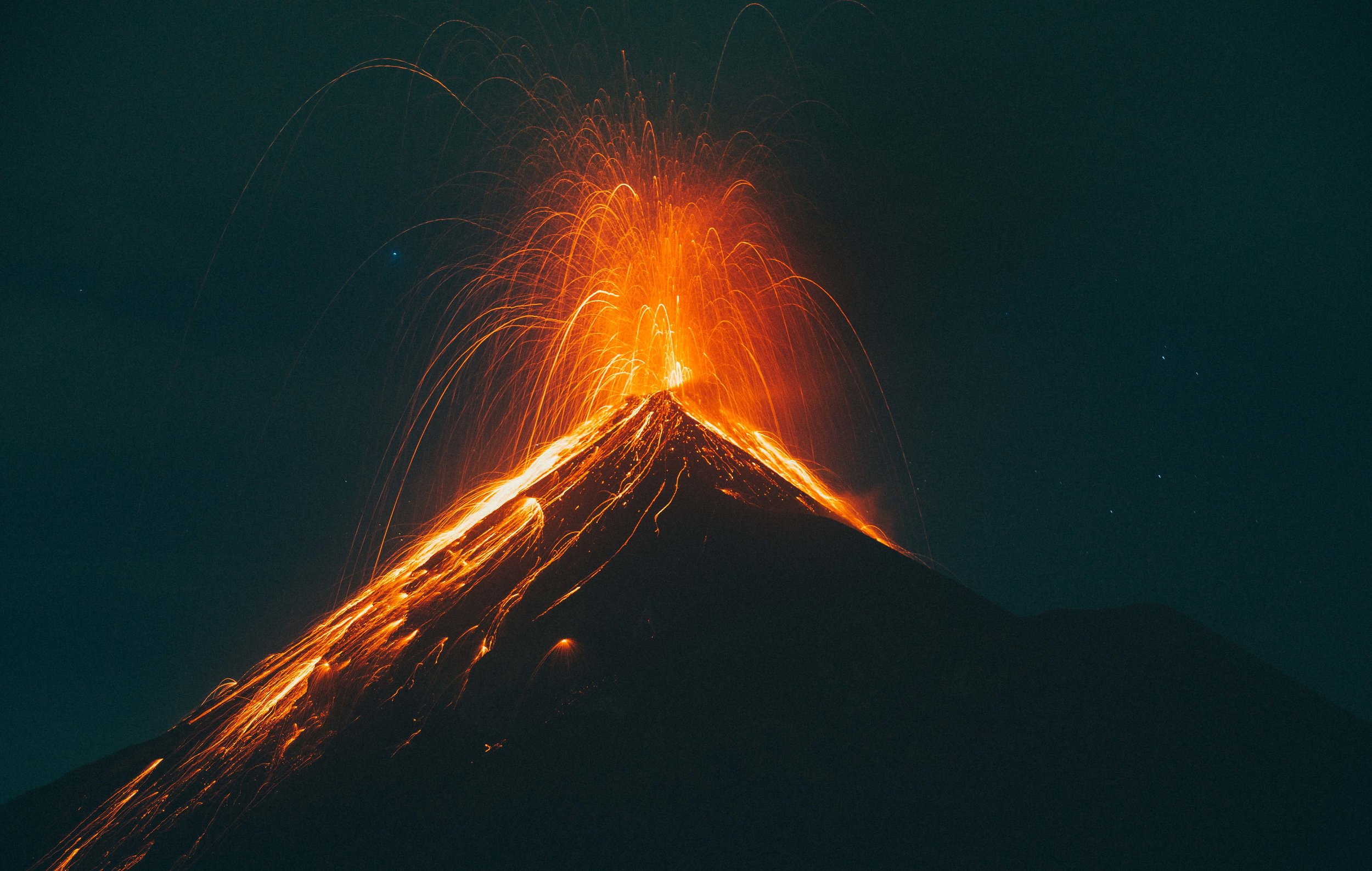
Volcan Fuego erupting after dark. We were so close that we could feel the ground shaking below us. Photo by John Guillote.

Warming up our frozen toes and drying out wet soles after a long hike up in the freezing rain.
After what seemed like an eternity shaking in our sleeping bags, the guides were miraculously able to start a fire! Shortly after we all huddled around the fire trying to dry our shoes and clothes and sipped hot tea. It took some time, but we finally warmed up enough to look around and take in just how beautiful our surroundings were. As the sun began to set, we ate our pasta dinner and drank our cups of red wine while watching Volcan Fuego erupt again and again. It was an incredible night and we still had the summit to look forward to.


At 4am the next morning we woke up with groggy eyes and cold limbs. We donned our head lamps, gloves and almost dry hiking boots and started for the summit. It was a windy and freezing morning with the cloud cover so thick that it felt like it was raining. Only half the group decided to make the final push to the summit. Rachel, Becca and I started slowly up the loose gravel trail.
We had thought the trail had been steep the day before, but today with tired legs we felt like we'd never make it to the top. Step by step, we constantly thought of turning around, rationalizing our retreat by saying the clouds were too thick to see anything from the summit, it was just too cold, Josh has a bad ankle.... On and on we came up with excuses, but right as we felt like we had enough reasons to turn back, the clouds began to clear and the summit reviled itself and the breathtaking views it held. Unfortunately, the same wind that cleared the summit and made these views possible, also ripped through our clothes to our skin, making it almost unbearably cold.

A stunning sunrise on the summit of Acatenango with Volcan Agua in the distance.

We would have loved to have taken more photos at the summit, but it was only possible to have bare hands exposed for a few seconds before the burning, numbness left our fingers useless. The way down was much easier, but still hard on the knees. For the last bit of the trail I found it easier to run, rather than try to slow myself down and strain my knees.

Group photo on the summit of Acatenango.
Back at camp breakfast and hot coffee was waiting for us! We sat and enjoyed the view of Fuego from the warmth of our tent as we filled our bellies and summoned the energy to decent the rest of the volcano.
We eventually packed up camp and began our trek down, enjoying the warming climate as we descended. It was truly an unforgettable experience and we highly recommend the trip to anyone who is up for an adventure!
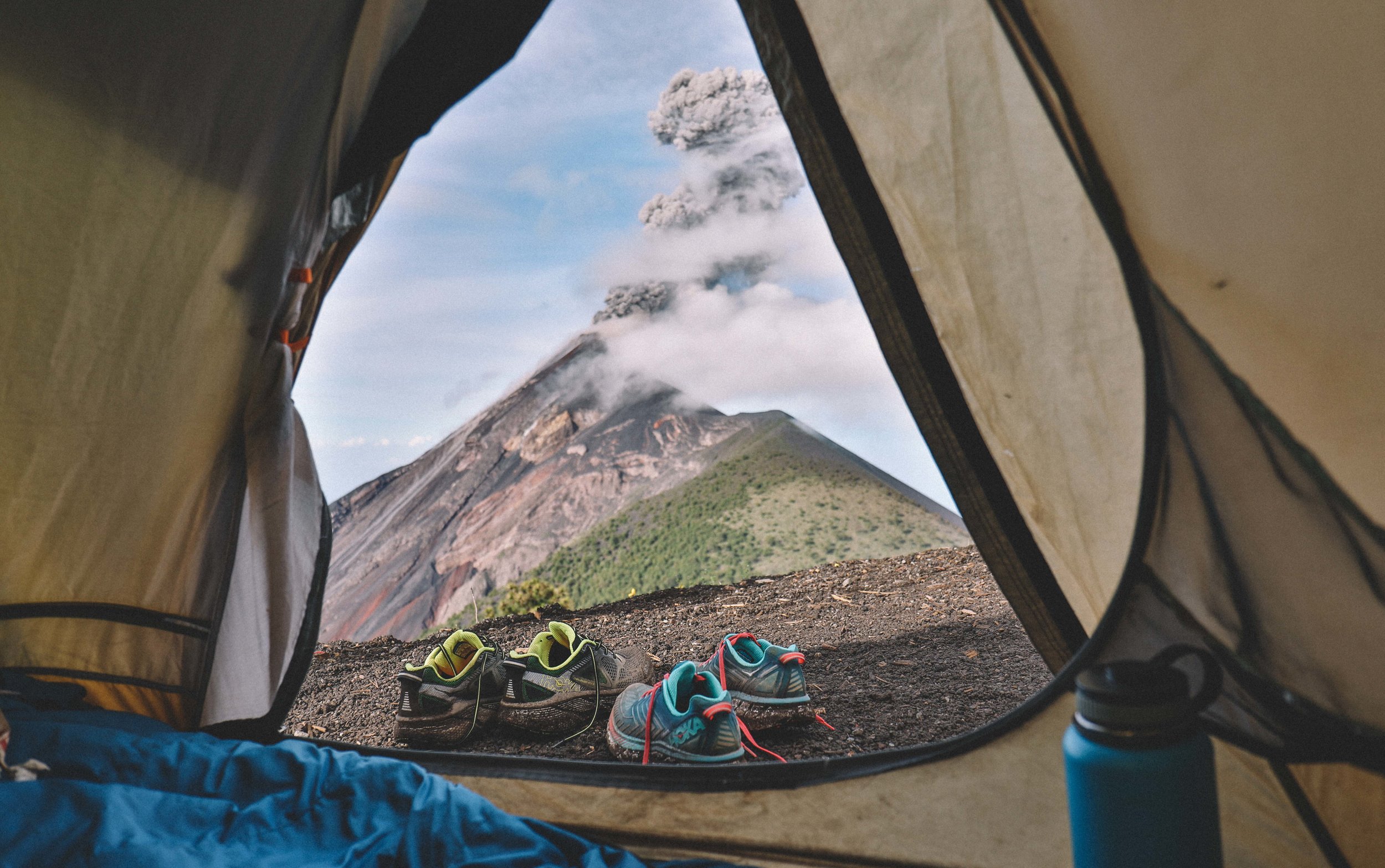
Our tent view!

Fuego erupting at sunrise. Photo by John Guillote.
The last couple of miles of the trail through the farm fields were fairly easy and I half ran, half stumbled down the mountain. As I stumbled my way down I kept getting this strange sensation on my lower back, around my hips. Turned out my not-so-great fitting rental pack, combined with the bouncing of jogging, wore away the skin on my bonny back/hips.


After descending the Volcano we were all exhausted and ready for some rest and relaxation. And what better place is there to relax than at Lake Atitlan?! At this point John and Becca had to start making their way back to Chiapas to finish decommissioning Halcyon and fly home. Rachel, Willie, Nicola and I hopped on a bus to the village of Panajachel on the shore of Lake Atitlan.

Lake Atitlán is renowned as one of the most beautiful lakes in the world and is one of Guatemala's most important national and international tourist attractions. The lake fills an enormous caldera that was originally formed by an eruption 84,000 years ago and is over 1,120 ft deep! The lake is surrounded by many villages in which Maya culture is still prevalent and the traditional dress is still worn. The Maya people of Atitlán are predominantly Tz'utujil and Kaqchikel and Atitlán means "between the waters" in the native Nahuatl language.

Lake Atitlan. Photo by Willie Kessel.
Last time we visited the lake we stayed at the hostel named La Iguana Perdida that is located in the village of Santa Cruz, a 15 minute boat ride from Panajachel. We loved their family style meals in a large dining area, where we sat with other travelers having amazing conversations. The food is delicious, the staff is friendly and helpful and the rooms are rustically charming. They even offer scuba diving here where you can swim through old lava tubes and put your hands in mud heated by the volcanic hot vents below the lake.
On this trip we decided to return to La Iguana Perdida again and stayed for three days, relaxing in hammocks and walking around the lake. It was nice to have a few days to do nothing and all day to do it. In a few days we'd be heading to the remote Semuc Champey and the Rio Dulce.
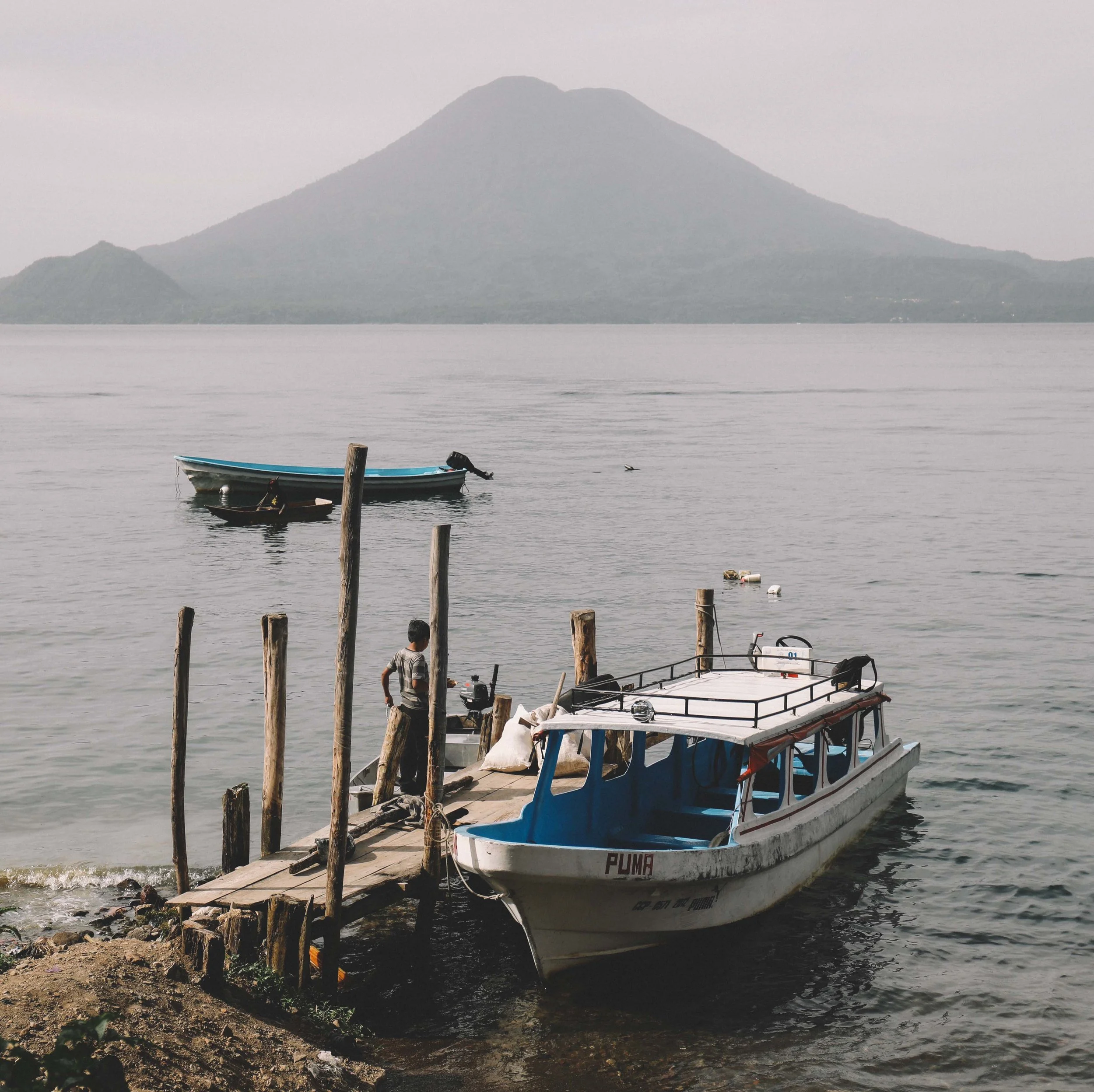
Photo by Willie Kessel

Photo by Willie Kessel